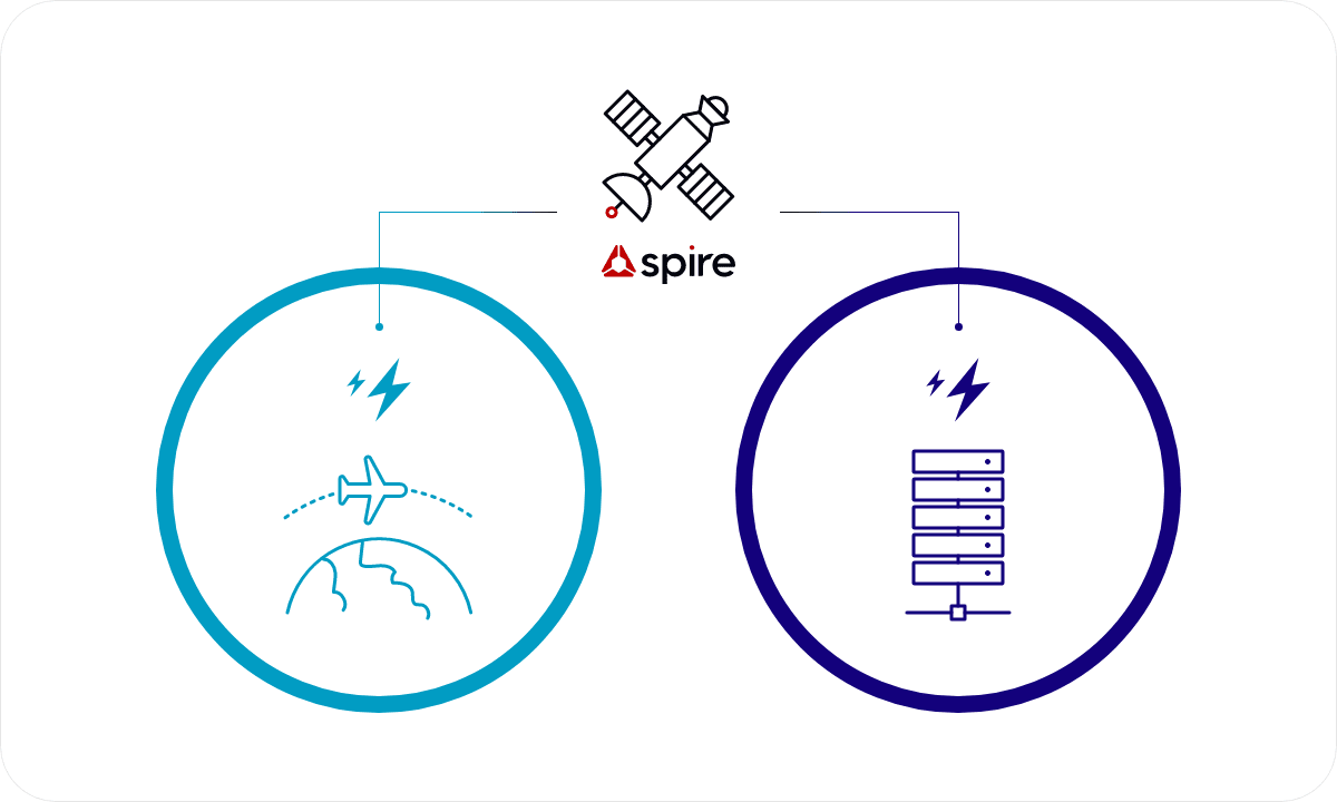
Spire Global

Spire Global provides a variety of data analysis, information, and solutions using artificial satellites,
including Earth's weather, maritime conditions, and the positions of aircraft and vessels.

  • Spire Global

Eco Marine is
Spire Global exclusive distributor.

Spire Global possesses a top-tier satellite infrastructure.

  • Satellite AIS
    Maritime

    AIS, transmitted by shipborne transceivers as a legal requirement, provides data collected by exactEarth & Spire satellites, on land and from maritime authorities, regarding ship locations.

  • Global Satellite Weather
    Weather

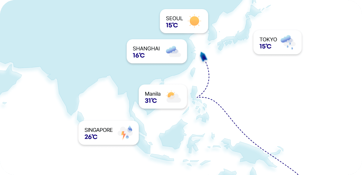
    Providing historical, current, and forecast weather data from around the world collected by Spire's satellites.

  • Satellite
    ADS-B
    Aviation

    ADS-B, transmitted by aircraft transponders as a legal requirement, offers aircraft identification services through Spire's satellites for tracking aircraft positions.

  • 30+

    Ground Station

  • 165+

    Satellite in Operation

Eco Marine is the official reseller of Spire Global in Korea.


Spire
Maritime

What is Satellite AIS?

AIS (Automatic Identification System) is a statutory device that automatically transmits the location of a vessel.
The system that collects ship location information by mounting an AIS receiver on a satellite is called satellite AIS.

  • Live
    AIS data

    provided worldwide via 100+ low Earth orbit satellites.

  • Real-time
    AIS data

    provided by exactEarth's satellite AIS service through Cross Link technology installed on satellites, ensuring zero latency.

  • Real-time
    AIS data

    service offering ship location information in shadow zones through AIS receivers attached to 3,500 vessels.

  • Historical
    AIS data

    Possessing a decade's worth of AIS data from 280,000 vessels worldwide.

  • Historical AIS Data

    Spire’s Historical AIS Data is a global archive providing the most complete picture of AIS history data on the market, for the most complete shipping analysis.
    Advancing filtering options including date and time range, geographical area, AIS message type, ship MMSI list, ship type, and vessel flag allow you to tailor the data to your unique requirements. Access to raw data is also available, allowing you to uncover information beyond what is captured in a live feed.

    Most complete historical AIS data set since 2010
    - No data gaps, allowing you to have complete coverage
    Strongest historical AIS dataset on the market
    - Enhanced with other data sources
    Ability to curate your exact data set with competitive pricing adjusted to your sample settings
    - Select vessels, date range, and area of interest most relevant to your business
    Flexible delivery formats, to adapt to your use case
    - CSV, JSON, NMEA, XML, KML, Shapefile or as density maps

    Historical AIS Data Use cases

    Historical AIS provides a valuable resource for retrospective analysis, trend identification, and informed decision-making. Gain insights into long-term maritime activities and behaviors, which can lead to improved operational efficiency, better resource allocation, and more accurate research outcomes.

    Container, goods performance / tracking for logistics
    - Optimize supply chain management, estimate transit times more accurately, and identify areas for operational improvements.
    - Analyze historical movement of cargo vessels over time.
    - Review past vessel routes, arrival times, and port activities to identify patterns and trends in logistics operations.
    Shipping operations
    - Invaluable data for tracking and managing shipping operations.
    - Assess historical fleet performance
    - By analyzing past routes, delays, and performance metrics, identify factors that contribute to operational inefficiencies, plan maintenance schedules, and make informed decisions to enhance overall fleet performance.
    Commodity / market intelligence
    - Study historical shipping trends, route changes, and cargo volumes to understand long-term patterns and anticipate market shifts.
    - Combining historical AIS data with other relevant information, such as global events or economic indicators, gain deeper insights into supply and demand dynamics for various commodities.
    University Research
    - Analyze historical vessel movements to study maritime traffic patterns, environmental impacts of shipping, or the effects of maritime regulations.
    - Use Historical AIS to support academic studies on maritime transportation, climate change, marine conservation, and other fields.

    Historical AIS data delivery options

    Whether you are interested in an API subscription or a one-time data buy, Spire Maritime can offer different delivery methods to adapt to your needs.

    One-time data purchase

    - One-time buy, no subscription
    - AIS historical data via a download link, SFTP or physical format
    - Cost adjusted to your specific sample settings

  • AIS Position Validation

    Advanced RF signal-based vessel detection and tracking to validate vessels’ positions based on the unique real time coverage offered by the Spire constellation.

    Using additional RF data through doppler frequency shift and associated accurate timing data collected at the time of receipt of transmitted AIS messages, AIS Position Validation independently calculates a vessel’s location at the time of AIS transmission (even if AIS messages do not include valid GPS data).

    This can be compared to the reported position contained within the AIS messages received from a vessel.

    - Continuous global coverage
    - Calculated position and timestamp in any given 24 hour period since October 2022
    - Distance between reported and calculated position
    - Range of event types, each with timestamp and timestamp
    - Real time information (data takes 20 mins to process)

  • Spire’s Standard AIS

    Spire Maritime’s leading Standard Automatic Identification System (AIS) vessel tracking data provides an up-to-date and accurate view of the world’s shipping activities.

    - Global ocean coverage based on our proprietary satellite constellation
    - All active AIS devices detected with over 600K vessels, 250K+ active vessels/day
    - Vessels you can track: 1) All vessels, 2) All vessels of a specific type, 3) A specific fleet, or 4) individual vessels with either AIS Class A or Class B transponders.
    - Static, positional and voyage related data
    - Near real time refresh near shore (average of 1 min)
    - Standard refresh in the Open Ocean (average of 6 mins)

    How Standard AIS works

    Spire’s Standard AIS provides unrivalled vessel tracking through our ever-expanding set of data sources.
    Spire Maritime’s Standard Satellite AIS is powered by our Low Earth Multi-Use Receiver (LEMUR) satellite constellation. This constellation, consisting of hosted VHF maritime receiver payloads, collects global radio frequency data in near-real-time from nanosatellites equipped with multiple sensors. The data is then delivered with low latency through the world’s largest network of ground receiving stations dedicated to small satellites. This satellite data forms the foundation of our service. We fuse this satellite data with information from various additional sources, such as terrestrial AIS stations, to provide a comprehensive view of maritime activities.
    This approach, combined with our globally distributed satellite operations and IT support teams, ensures a reliable and continuous service.
    With the largest team of Satellite AIS technology experts and specialists in the world, Spire Maritime is committed to delivering world-class capabilities to our customers.

    Why choose Spire Maritime?

    Most complete source of AIS data
    Spire Maritime has the largest constellations and highest volume of messages tracked by satellite. Combined with other trusted data sources, we offer the most complete picture of AIS data on the market.
    Track vessels anywhere and at any moment in time
    Increase your situational awareness by accessing vessel positions worldwide or in areas of interest.
    Leverage accurate and actionable data
    Make better‑informed decisions, even in highly congested traffic areas, with enhanced vessel detection. Maintain a competitive edge
    Create strong domain awareness based on high data quality and accurate information.
    Resource efficiency
    Free up your most valuable resource, your team, by leveraging Maritime 2.0 GraphQL for cleansed data and platform extensibility.

    Standard AIS data Use cases

    Container, goods performance / tracking for logistics
    - Track cargo vessels carrying containers and goods.
    - See progress of shipments, estimate arrival times, and improve supply chain management.
    - Identify potential delays or disruptions in the logistics chain.
    Commodity / market intelligence
    - Insights into shipping activities related to commodities to make informed decisions in commodity trading and investment.
    - Analyze vessel movements and traffic patterns, assess shipping volumes, identify trends in commodity transportation, and anticipate potential supply chain disruptions.
    Vessel performance / route optimization
    - AIS data supports voyage optimization by providing information about vessel performance and route efficiency.
    - Make informed decisions to optimize routes for fuel efficiency, reduced emissions, and shorter transit times, leading cost savings and improved environmental sustainability.
    Shipping operations
    - Invaluable data for tracking and managing shipping operations.
    - Assess historical fleet performance
    - By analyzing past routes, delays, and performance metrics, identify factors that contribute to operational inefficiencies, plan maintenance schedules, and make informed decisions to enhance overall fleet performance.

  • Real-time AIS vessel tracking data

    Spire Maritime’s Real‑time Automatic Identification System (AIS) provides an up-to-date and accurate view of the world’s shipping activities.

    Real-time AIS is based on an interconnected satellite architecture to provide real time coverage and instant visibility into maritime activities, in the open ocean and near shore.

    - Latency: less than 1 minute in the open ocean
    - Global ocean coverage based on our proprietary satellite constellation
    - All active AIS devices detected with over 600K vessels, 250K+ active vessels/day
    - Vessels you can track: 1) All vessels, 2) All vessels of a specific type, 3) A specific fleet, or 4) individual vessels with either AIS Class A or Class B transponders.
    - Static, positional and voyage related data

    How Real-time AIS works

    Spire Maritime’s Real-time Satellite AIS is powered by a system of advanced VHF maritime satellite payloads hosted on the Iridium NEXT satellite constellation. These payloads collect global radio frequency data in near-real-time from satellites equipped with multiple sensors. The data is then delivered in real-time through the satellite system’s in-orbit ‘mesh’ architecture, which ensures continuous global surface coverage.

    This real-time satellite data forms the foundation of our service. We fuse this satellite data with information from various additional sources, such as terrestrial AIS stations, to provide a comprehensive view of maritime activities. This approach, combined with our globally distributed satellite operations and IT support teams, ensures reliable and continuous service. With the largest team of SAT-AIS technology experts and specialists in the world, Spire Maritime is committed to delivering world-class capabilities to our customers.

    Why choose Spire Real-time AIS?

    Only constellation providing Real-time AIS on the market Track vessels activities anywhere as they happen
    Increase your situational awareness by accessing real‑time vessel positions in waters of interest
    Most complete source of AIS data
    Access the largest constellations and highest volumes of messages tracked by satellite. Combined with other trusted data sources, we offer the most complete picture of AIS data on the market
    Unique domain awareness
    Based on high quality data and accurate information, track any vessels, including for a specific vertical, customers or competitor

Utilizing the AI technology owned by Eco Marine,
we provide data processing services.


Spire
Weather

Global Satellite-Based Weather System

The Spire Weather service utilizes Radio Occultation technology from over 100 meteorological satellites, collecting thousands of atmospheric data points daily. It monitors pressure, humidity, temperature, and more, from around the world and especially from remote and maritime regions.

[ Spire 100+ Radio Occulation ]

Spire provides historical, current, and future forecast data collected from 100+ Radio Occultation satellites.

  • Historical Data.

    Possessing 30 years of global historical data.
    (Updated every 1 hour)

  • Current Data.

    Updating global weather on an hourly basis.
    (3 km resolution)

  • Future Data.

    Predictive data for global or regional forecasts.
    (10 days forecast)

[Maritime Specialized Features]

Through maritime-focused weather capabilities, we offer services for optimal recommended routes for ships, as well as weather and forecast information specific to ports.

  • Providing optimal recommended routes for ships.

    Spire Weather utilizes weather sensors, Spire's satellite weather observations, and other sources to learn weather patterns in specific regions, combining machine learning techniques to create accurate forecasts.

  • Port-specific weather and forecasts.

    Accessing customized weather forecasts for specific locations, allowing efficient work planning and ensuring maximum accuracy, thus enhancing business productivity.

  • Maritime Weather Data

    Spire Weather is a unique solution for a reliable global weather forecast powered by the largest private weather observation satellite constellation.

    Maritime Weather portfolio

    Voyage Optimization
    A multi-objective voyage optimization algorithm. Calculating routes based on all key drivers behind voyage decision making.
    Complete solution delivered through API and integrated with Spire’s satellite-based weather forecasts.
    Flexible to meet your technology infrastructure. Can be delivered with built-in vessel performance models or integrated to your in-house developed ones.

    Global Weather Forecast
    15-day weather forecast anywhere on the planet, in 12-km (1/8-th degree) resolution.
    Dozens of weather parameters for the atmosphere and oceans, with multiple packages dedicated to the Maritime industry (including probabilistic forecasts).
    Available for Global download (GRIB2), per coordinate or per vessel route retrieval (JSON).

    Historical Weather
    Historical weather data anywhere on the planet since 1990.
    Available in 12-km (1/8-th degree) resolution.
    Integrated with AIS historical data to easily retrieve the weather conditions faced by vessels in the past.
    Also available for global download (GRIB2).

    Port Weather Forecast
    A dedicated weather forecast for ports, with hourly weather for the next 15 days.
    Weather forecasts updated every hour.
    Forecasts tuned individually for each port, combining local observation with different weather models by using advanced ML techniques.

    Maritime Insights
    Maritime Insights delivers a forecast of the weather impact to shipping operations.
    Based on the vessel characteristics, load, and a desired route, the API can calculate a forecast of the weather risk for the cargo, crew, and vessel, or the range of impact the weather has on the vessel performance.

    Storm Tracks
    Historical, current, and forecast tropical cyclone tracks with aggregated data from the NHC, CPHC, and JTWC.
    Global coverage, all basins.
    Available in JSON or KMZ for visualization.

    Current Weather
    Global high-resolution (3-km) overview of current weather conditions.
    10 atmospheric variables available, updated every hour.

    Tides Global astronomical tides data from 1990 to five years from now.
    Hourly tides or peaks, available in JSON format.

Collecting data from ports and 10,500 weather observation stations to provide forecasts.


Spire
Aviation

What is ADS-B?

ADS-B stands for Automatic Dependent Surveillance - Broadcast. It is a system that autonomously collects aircraft information such as position, altitude, and speed at regular intervals. It plays an increasingly vital role in various aspects of the aviation industry, contributing to safety and efficiency enhancements.

  • Tracking
    Data

    Real time/past
    Flight tracking service
    API provided

  • Aircraft &
    Airline Fleet
    Data

    Tail Number, Aircraft Code, Aircraft Code Type name, Airline code, Airline name

  • Flight
    Schedule/
    Airport Data

    Flight Number, Departure time, Arrival time, Departure Aircraft Code, Arrival Aircraft Code, IATA and ICAO codes

  • Flight
    Analytics

    Estimated time of arrival estimated time of departure Takeoff time, Landing time

  • Global flight and aviation insights

    Easily access live and historical flight information
    - Airline KPIs – OTP, cost and performance insights, fuel burn insights
    - Airport insights – off/on block time, holdings, gate and runway information
    - Top operators, airports, destinations
    - Routes data and carbon emissions insights
    - Overflight information – Flight Information Regions(FIR), billing, entry/exit times
    - Aircraft utilisation insights
    - Travel and cargo capacity insights
    - Fleet insights

  • Simplified data processing and real time insights and Use cases

    Air Cargo & Logistics
    - Track & Trace your shipments
    - Smarter digital operations with automated flight alerts
    - Market intelligence about cargo capacity and airport congestion
    Aviation sustainability solutions
    - Fuel optimization and flight analytics
    - Build carbon emissions models and offset tools
    - Contrail management solutions
    Insurance, MRO & aircraft leasing
    - Most up-to-date overview of your aircraft utilization (hours and cycles)
    - Airline OTP/TAT performance and network analysis
    - Risk management for monitoring aircraft asset exposure and contract compliance